


Fom the Forest Science and Technology Centre of Catalonia (CTFC) and the FIRE-RES team, we would like to express our condolences to the families and friends of the victims of the Torrefeta and Florejacs wildfire in La Segarra.
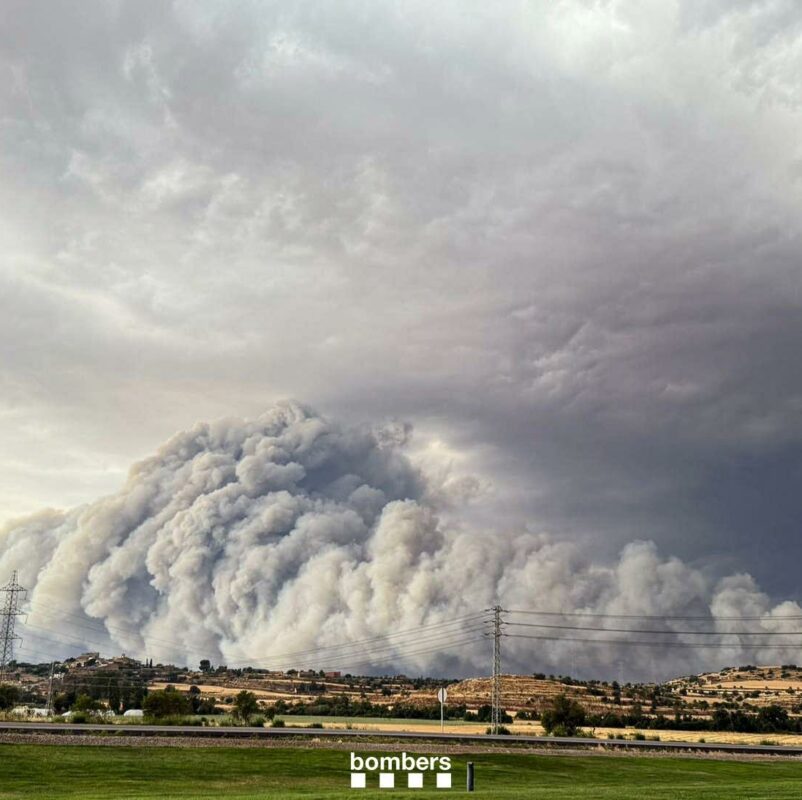
On the 1st of July of 2025, a wildfire broke out in Segarra, killing two people, slightly injuring two firefighters, affecting an area of about 5,500 ha and burning a farmhouse, 2 sheds, 3 farms and a building. This wildfire had an extreme behaviour, with propagation speeds of up to 28 km/h (one of the highest ever recorded in Europe) and generating a 14 km high pyrocumulus and impacting an area 40 km long.
This wildfire took place in a landscape with little forest area, but where the cereal fields were about to be harvested or with the straw to be collected. The affected area is therefore a homogeneous landscape and remains very vulnerable during this harvesting period due to the large accumulation of straw and grass that the spring rains had made grow and were now dry.
The wildfire spread with extreme behaviour due to pyroconvection processes generated due to the large amount of energy released in a short time when the amount of fine fuel available was burning. The unstable atmosphere and the interaction with the two storm fronts also contributed to it. This same phenomenon has been observed and studied in Chile, Portugal, the Landes or California.
As a result of the developed pyroconvection and the interaction with the storms, the column of smoke was dense enough to have to confine the population in the 26,000 ha around the wildfire. In addition to the usual communication channels, the ES-ALERT system was used to warn the population of the situation and how to act (confinement). These guidelines for action and recommendations are key to creating the necessary risk awareness so that the population can collaborate with the management of the emergency itself.
The FIRE-RES project is a large European project led by the CTFC and with the participation of the Fire Department of the Generalitat and other entities of Catalonia, which focuses on the study of extreme wildfires in which phenomena such as those that have occurred in the Torrefeta and Florejacs wildfire occur, pyroconvection phenomena that include the coupling of fire with the atmosphere generating a pyrocumulus. The project’s main objectives are the development and implementation of innovations and solutions applied in large study areas throughout Europe and Chile. This scenario of extreme wildfires, uncertain in their development and difficult to predict, is becoming increasingly frequent due to climate change that has been manifesting itself unequivocally in recent years.
This wildfire highlights some of the CHALLENGES that were defined at the beginning of the project:
- A mosaic landscape reduces the risk of extreme behaviours but does not eliminate them if it accumulates enough biomass to release the critical energy for pyroconvection phenomena in adverse environmental conditions. This accumulation and continuity of biomass could be reduced by increasing the diversification of forest and crop types.
- The landscape is dynamic, and constant monitoring is necessary to identify risk situations. In the case of extreme wildfires, this involves monitoring the available biomass load that will be transformed into energy to feed pyroconvection processes.
- Monitoring meteorological variables at the surface is not sufficient to anticipate risk situations. It is necessary to identify the key atmospheric variables that describe convection processes in the upper layers of the atmosphere to assess the risk of having extreme situations and monitor them.
- Promote the culture of risk in the population so that it forms part of the management of the territory and the emergency in these new extreme wildfire scenarios, with the dissemination and interaction of knowledge and learning, thus promoting the culture of self-protection and co-responsibility in decision-making.
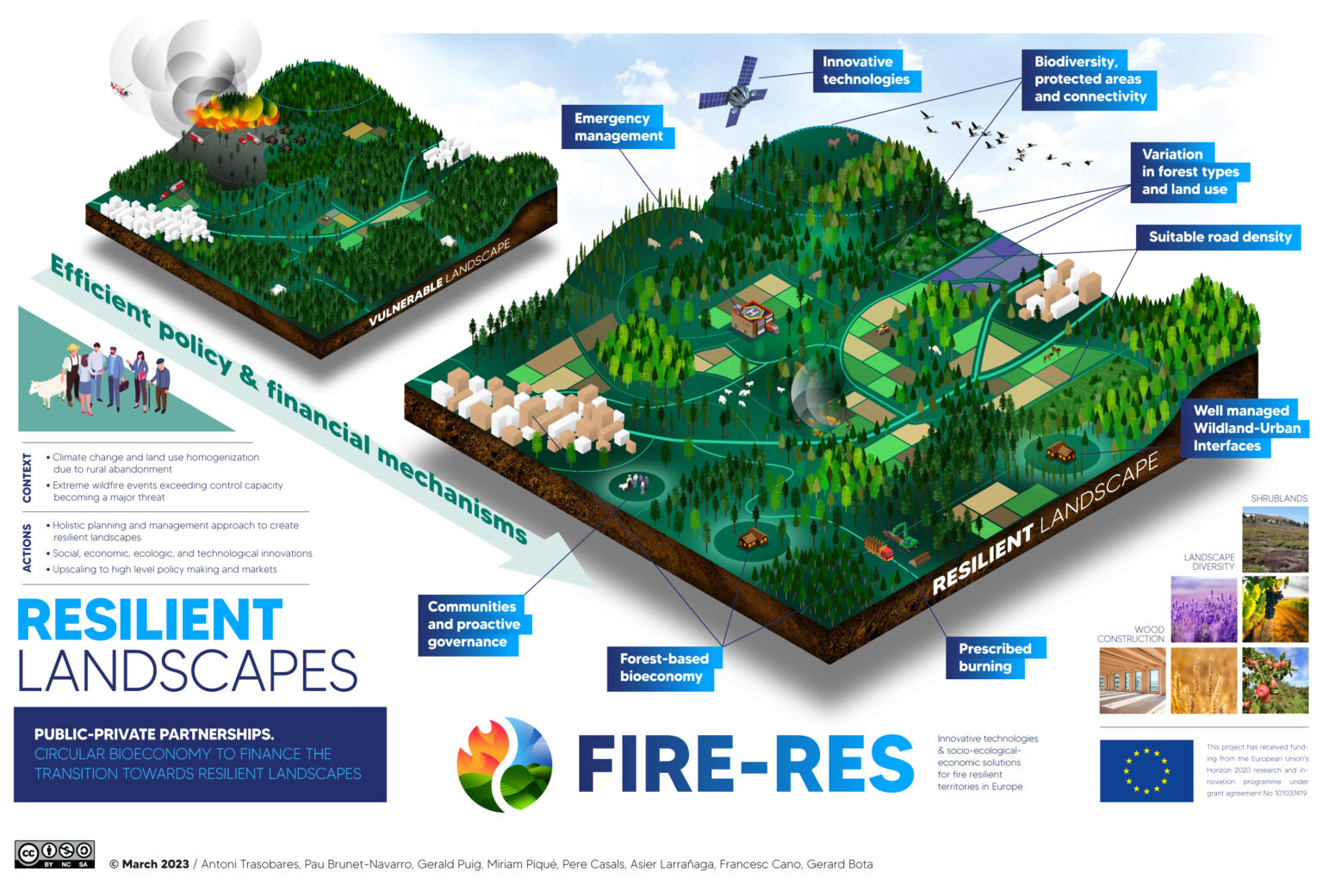
Figure 1: Resilient landscape concept promoted by FIRE-RES.
Some of the Innovative Actions that are being developed and implemented within the framework of the FIRE-RES project linked to wildfires such as the Segarra fire are:
- Adaptation of fire polygons to assess the impact of extreme wildfires and define the priorities of strategic objectives during the emergency. The fire polygon methodology has been adapted to the complex and uncertain scenarios of extreme wildfires, allowing the identification of a strategic scenario for decision-making during the emergency. More information on the project website.
- Atmospheric data analysis using new knowledge and experience in extreme wildfire behaviour. The analysis of extreme wildfires requires new atmospheric parameters to understand pyroconvection processes and fire-atmosphere interaction. More information on the project website.
- Landscape design strategies, using tactical planning methods. Combines fire simulation models with forest growth simulators, and optimization techniques, to develop landscape-level plans and policies that can minimize expected losses from large fires while meeting socio-economic sustainability criteria. More information on the project website.
- Financial incentives for landscape measures to improve wildfire resistance and implementation of the bioeconomy. System of credits and/or subsidies to transfer funds collected from the beneficiaries of the resilience of a landscape (for example, tourism) to cover the additional costs derived from the implementation of prevention, preparation and adaptation measures. Incentivize value chains and economic activity that makes territorial management viable. More information on the project website.
- Improving governance through policy coherence. New public-private mechanism for participatory discussion at regional level to identify which policy sets work or do not work for coherent governance of fire risk, across all phases of risk management and multi-hazard interactions. More information on the project website.
- Real-time simulation of large wildfires and smoke propagation based on coupled fire-atmosphere approaches using high-altitude meteorological data. Coupled fire-atmosphere propagation model to consider the effect of pyroconvection on fire behaviour, progression and impact estimates. Includes inlet currents derived from smoke columns as well as improved high-resolution meteorological models. More information on the project website.
- Smart fire planning platform and conceptualization tool. Specific online platform on wildfire-related guidance for land use planners. It aims to become the reference point for landscape architects, urban and spatial planners. More information on the project website.
- Quantification of the impacts of exposure to atmospheric pollutants from wildfires. New system for monitoring air quality in areas affected by wildfires, using sensor technologies and passive dosimeters (for Volatile Organic Compounds and NO2). More information on the project website.
- Adaptation of tools for international collaboration by sharing operational information between specialized stakeholders. Implementation of a web portal module with operational information for emergency management and the decision-making process with the aim of facilitating the monitoring and management of extreme wildfires. As an example of the implementation of this innovative action, the Ministry of the Interior of Catalonia provides real-time information through a website that contains a viewer and messages agreed between Civil Protection, Mossos d’Esquadre (Catalan police) and Fire Brigade on prevention and how to act in the event of a wildfire. This same website has a section on wildfires and new scenarios where there is a section dedicated to extreme wildfires with a description of the scenarios and data as well as a reference to FIRE-RES. More information on the project website.
The project is reaching its final phase and during the autumn of 2025 the results will be presented at the highest technical and political level to the European Commission, in Brussels. It is also planned to evolve the project towards a continuous program format with the implementation horizon of 2030, which aims to consolidate the results achieved in this first phase and replicate them at an international level.
By the end of the summer, it is planned to publish the main conclusions and recommendations reached by the Community of Wildfire Innovation of Catalonia (Comunitat d’Innovació sobre Incendis Forestals a Catalunya (CIIFCat), in Catalan), within the framework of this project.
More information: https://fire-res.eu/
Last modified: 6 July 2025


